Building a portfolio-worthy photography itinerary requires shifting from a tourist’s mindset to a location manager’s production-based approach.
- A successful trip is built around a cohesive visual narrative, not just a list of scenic spots.
- Logistical efficiency and managing environmental variables are as crucial as creative composition.
Recommendation: Structure your itinerary using a “hub-and-spoke” or “linear loop” model based on your trip’s length and flexibility needs to maximize your shot economy.
As a visual creator, the goal of a multi-landscape trip isn’t just to capture beautiful images; it’s to build a cohesive, compelling portfolio. Many photographers approach this by creating a checklist of “hero” shots—a coastal sunrise, a mountain vista, a desert dune. The result is often a collection of disconnected postcards rather than a powerful visual story. The common advice to “research locations” and “chase the golden hour” is valid but incomplete. It addresses individual shots, not the entire production.
The fundamental flaw in this approach is the lack of a unifying concept. What if the key wasn’t just finding locations, but connecting them through a clear narrative thread? This is the production mindset of a location manager. It involves treating your itinerary not as a vacation, but as a film scout. Every decision, from the travel route to the time of day, serves the larger story you’re trying to tell. This shift in perspective transforms your planning process from a logistical headache into a creative act.
This guide provides a framework for building that production-level itinerary. We will move beyond simple location-hopping and focus on creating a visual narrative. We’ll explore how to structure your travel for maximum efficiency, how to anticipate and master the unique environmental variables of each biome, and how to handle the critical technical and legal challenges that can make or break a shoot. By adopting this methodical approach, you can ensure your journey from coast to mountain to desert yields a body of work that is not only stunning but also deeply coherent.
This article breaks down the entire process, from establishing a narrative concept to mastering the on-the-ground logistics. Follow this guide to build an itinerary that delivers a truly professional and diverse portfolio.
Table of Contents: A Guide to Building Your Multi-Biome Itinerary
- Why the DR Is Called a “Micro-Continent” by Geographers?
- How to Fly Your Drone Legally in National Parks?
- Where Is the Best Sunset Viewpoint: Mountain Peak or Ocean Horizon?
- The Weather App Mistake That Ruins Scenic Drives in the Mountains
- In Which Order Should You Travel to Minimize Drive Time Between Sceneries?
- How to Photograph the White Sands Without Overexposing Your Shots?
- How to Plan a Mountain Retreat in the Central Cordillera?
- How to Train and Prepare for the Pico Duarte Expedition?
Why the DR Is Called a “Micro-Continent” by Geographers?
The term “micro-continent” isn’t just a geographical label; it’s a powerful creative concept for a location manager. It signifies a destination where vastly different biomes—like coasts, mountains, and arid landscapes—exist in close proximity. This density offers an incredible opportunity for visual storytelling. Instead of capturing isolated scenes, you can document the transitions between them, creating a narrative of ecological diversity. The Dominican Republic is a classic example, but this principle can be applied anywhere, from Morocco’s journey from the Atlantic to the Sahara to California’s own diverse landscapes.
Building your itinerary around this concept requires a narrative-first approach. You’re not just scouting locations; you’re scouting a story. This story might follow a river from its mountain source to its coastal delta or trace an ancient trade route through changing elevations. The key is to find the connecting threads that tie your disparate landscapes together into a cohesive whole. This establishes a strong foundation for your entire project.
This visual progression, moving from an expansive coast to dramatic mountains and finally to a minimalist desert, creates a classic three-act structure. It provides a natural arc for your portfolio, showcasing your ability to work across and connect different environments. To formalize this, a location manager would build a framework to guide the scouting process, ensuring every chosen spot serves the overall narrative.
Framework for Finding Your Itinerary’s Narrative Theme:
- Research the story: Investigate the geological or historical narrative of your destination. Look for unique transitions like river systems from source to sea or ancient migration routes.
- Map transition zones: Identify the visual seams between different biomes. These areas, where one landscape bleeds into another, are powerful storytelling locations.
- Create a visual arc: Structure your shot list like a film: start with wide establishing coastal shots (Act 1), move to dramatic mountain “conflict” (Act 2), and end with minimalist desert “resolution” (Act 3).
- Build thematic scaffolding: As confirmed by a framework from Visual Wilderness on planning, you should identify contrast points and transition zones rather than just individual locations.
- Document connecting elements: Photograph the details that link the landscapes—the same species of plant adapted to different climates, or the changing color of the soil—to visually unify the story.
By using this framework, your itinerary becomes more than a list of places. It becomes a production plan for a short film told in stills, demonstrating a higher level of creative and logistical thinking.
How to Fly Your Drone Legally in National Parks?
The short and non-negotiable answer for most prominent parks, especially in the United States, is that you cannot. For a drone pilot, understanding and respecting no-fly zones is the first rule of professional conduct. Flying a drone in a U.S. National Park has been banned since 2014, and the penalties are severe. This isn’t a guideline; it’s a hard legal boundary that dictates a significant part of your itinerary planning.
Attempting to bypass these rules is not only unethical but also carries substantial risk. According to National Park Service regulations, violators can face a maximum penalty of a $5,000 fine and up to six months in jail. For a professional, such a violation could mean the loss of equipment, a criminal record, and severe damage to your reputation. A location manager’s job is to mitigate risk, not create it. Therefore, the primary task is to plan *around* these restrictions, not through them.
This means your scouting must differentiate between National Park land and adjacent areas like National Forests or Bureau of Land Management (BLM) territories, where regulations are often different and may permit drone use with certain stipulations. Apps like B4UFLY or AirMap are essential tools for identifying these boundaries with precision. Your itinerary must clearly delineate where the drone can and cannot be deployed. This might mean capturing a mountain range from a viewpoint just outside the park boundary, which often offers a unique and less-photographed perspective anyway. The constraint, in this case, forces creativity and more thorough scouting.
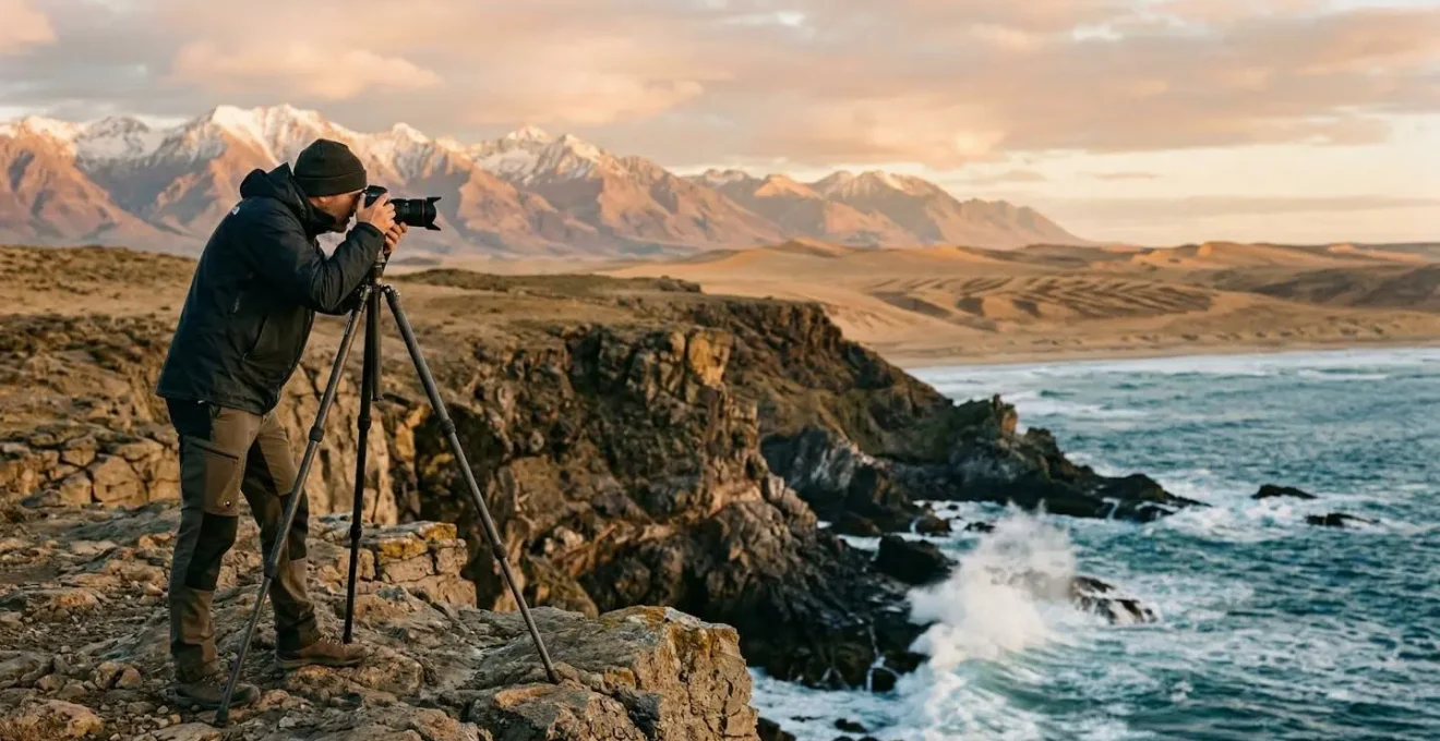
Where Is the Best Sunset Viewpoint: Mountain Peak or Ocean Horizon?
From a location manager’s perspective, this question isn’t about which is “better,” but which best serves the visual narrative and offers the most photographic opportunities. Both mountain peaks and ocean horizons provide spectacular sunset light, but they present entirely different sets of assets and challenges. The choice depends on the story you’re telling: the dramatic, layered complexity of the mountains versus the clean, minimalist simplicity of the coast.
A mountain peak offers natural layers and a multitude of focal points. You can create compositions with foreground rocks, mid-ground ridges, and a distant, colorful sky. The key light phenomenon here is often the alpenglow, a rosy light that illuminates peaks *after* the sun has dipped below the horizon. This extends your shooting window. Furthermore, mountains interact with weather in a visually dynamic way; dramatic clouds that might ruin a beach sunset can add immense depth and mood to a mountain scene. Valleys below can fill with fog or city lights, providing secondary subjects during the blue hour.
The ocean horizon, by contrast, is a masterclass in minimalism. It’s about negative space, clean reflections, and the singular drama of the sun meeting the water. For photographers, this is an opportunity for long exposure effects—smoothing the water into a silky, ethereal surface. Under perfectly clear conditions, you may even capture the elusive “green flash.” The blue hour over the ocean is particularly potent, as the water reflects the sky’s deep, saturated colors, creating a powerful, immersive color field. A successful ocean sunset shot relies heavily on clean conditions and a compelling, simple composition.
A professional evaluates these options with a trade-off analysis, weighing the creative potential against the logistical and environmental variables.
| Aspect | Mountain Peak | Ocean Horizon |
|---|---|---|
| Light Phenomena | Alpenglow (occurs after sunset) | Green Flash (clear conditions only) |
| Composition Assets | Natural layers & foreground elements | Clean reflections & negative space |
| Technical Advantages | Multiple focal points for depth | Long exposure water effects |
| Blue Hour Opportunities | City lights in valleys below | Silky water & sky color reflections |
| Weather Flexibility | Dramatic clouds add interest | Requires clearer conditions |
As this analysis of landscape photography opportunities highlights, the decision is strategic. For a narrative requiring depth and complexity, the mountain is superior. For a story centered on peace and minimalism, the ocean provides the ideal canvas.
The Weather App Mistake That Ruins Scenic Drives in the Mountains
The single biggest mistake a creator can make when planning a mountain shoot is trusting a single, macro-level weather app. Relying solely on your phone’s default weather forecast is like trying to navigate a maze with a map of the world. Mountains create their own weather systems, or microclimates, where conditions can change drastically from one valley to the next. A forecast showing “partly cloudy” for the region is useless when your target peak is socked in with fog while the valley below is in full sun.
A location manager doesn’t just check the weather; they analyze multiple data layers to build a comprehensive forecast. This “triple-check” workflow mitigates the risk of a wasted drive to a viewpoint with zero visibility. It involves cross-referencing different forecast models, seeking real-time ground truth, and understanding how topography shapes local conditions. For instance, knowing which side of a ridge is the windward (wetter) versus the leeward (drier) side can help you predict where clouds will form and where you might find a “rain shadow” with clear skies.
This understanding of topography is crucial. Valleys are prone to fog accumulation, especially in the morning. Wind can be funneled and intensified through certain passes. This isn’t just meteorology; it’s a vital part of landscape photography that allows you to be in the right place when dramatic light appears, often on the edge of a passing storm system. A professional workflow for mountain weather goes far beyond a simple app.
To truly master mountain conditions, a systematic approach is necessary. An effective workflow, drawing on principles from advanced landscape photography planning, involves several layers of verification:
- Layer 1 (Macro Trends): Use general apps like AccuWeather for multi-day patterns to understand the big picture.
- Layer 2 (Model Comparison): Utilize services like Windy or Pivotal Weather to compare professional forecast models (e.g., ECMWF vs. GFS). Discrepancies between models often indicate unstable or unpredictable conditions.
- Layer 3 (Ground Truth): Before committing to a location, check real-time data from local webcams, regional weather stations, and mountain observatory sites. This is your most accurate source for current conditions.
- Bonus (Topographic Analysis): Learn to read topographic maps to anticipate microclimates. Identify potential rain shadows, areas prone to valley fog, and wind-funneling effects.
This methodical process turns weather from a source of frustration into a predictable variable, allowing you to plan your mountain drives with confidence.
In Which Order Should You Travel to Minimize Drive Time Between Sceneries?
For a location manager, time is a non-renewable resource. Optimizing your travel route is fundamental to maximizing your “shot economy”—the number of high-quality creative opportunities you can capture for the time and energy invested. The question of travel order boils down to two primary logistical strategies: the Hub-and-Spoke model and the Linear Loop. The right choice depends entirely on the length of your trip, your tolerance for daily relocation, and the geographic distribution of your target locations.
The Hub-and-Spoke model involves setting up a basecamp in a central location for several days and making daily excursions to surrounding spots. This approach is excellent for shorter trips (4-7 days) or in regions with a high density of locations within a 1-2 hour drive. Its main advantage is logistical simplicity and flexibility. You unpack only once, reducing daily fatigue. If weather ruins a planned shot at one location, you can easily pivot to another or return to the same spot the next day for a second attempt. The downside is that your access to golden hour light is limited to the radius you can comfortably drive before sunrise and after sunset.
The Linear Loop is a progressive journey where you move to a new location and new accommodation each day, typically in a large circle or one-way route. This is ideal for longer trips (7-14+ days) designed to cover vast distances. Its primary benefit is maximum location coverage. Every sunrise and sunset happens at a new, unique location, dramatically increasing the diversity of your portfolio. However, this strategy is more demanding. It involves constant packing and unpacking, more total driving time, and less flexibility to revisit a spot if conditions aren’t right. It requires meticulous planning and a higher energy level.
Choosing between these two strategies is a critical decision that shapes the entire production. The following table breaks down the key trade-offs.
| Strategy | Hub-and-Spoke | Linear Loop |
|---|---|---|
| Base Changes | Stay in one location 3-4 days | Change accommodation nightly |
| Driving Pattern | Return to same base each night | Progressive movement forward |
| Best For | Weather flexibility, repeat shots | Maximum location coverage |
| Energy Management | Less packing/unpacking fatigue | More driving, constant movement |
| Golden Hour Access | Limited to 1-hour radius | New locations each sunrise/sunset |
| Ideal Trip Length | 4-7 days per hub | 7-14 day journeys |
As detailed in professional landscape photography guides, this choice is the foundational “logistical scaffolding” of your itinerary. A hybrid approach is also possible, linking 2-3 smaller hubs together in a larger linear journey.
How to Photograph the White Sands Without Overexposing Your Shots?
Photographing a landscape of brilliant white sand, like White Sands National Park, presents a significant technical challenge: your camera’s light meter will be deceived. Faced with a vast, bright scene, the meter tries to render it as a neutral middle gray, resulting in underexposed, muddy-looking images. The key is to consciously override your camera’s automatic impulses and take manual control to capture the scene’s true high-key nature without losing crucial detail.
The primary tool for this is your histogram. The goal is to “touch the right wall”—pushing your exposure as far to the right as possible without “clipping” or blowing out the highlights. This ensures the sand is rendered as a clean white while retaining subtle textures. Often, this requires adding positive exposure compensation (+0.7 to +1.5 EV) to what the meter suggests. It feels counterintuitive to add light to an already bright scene, but you are correcting for the meter’s inherent bias.
Beyond exposure, managing reflections and color is vital. The gypsum sand crystals create millions of microscopic reflections that can reduce contrast and hide texture. A circular polarizer is an essential tool to cut through this glare, deepening the blue sky and revealing the delicate ripples in the sand. White balance should also be set manually to a cooler temperature (around 5000-5500K) to counteract the warm reflections and maintain a pure white tone.
Mastering these high-key scenes requires a specific set of techniques:
- Control White Balance: Start with a cooler white balance setting (5000-5500K) to neutralize the warm reflections from the sand and achieve a clean white.
- Use the Histogram: Employ the “expose to the right” (ETTR) technique. Push your exposure so the histogram data approaches the right edge without significant clipping to capture maximum detail in the bright sand.
- Deploy a Polarizer: A circular polarizer is non-negotiable. It cuts reflections from individual sand crystals, enhancing texture and saturating the sky.
- Protect Highlights: Consider slight underexposure (-0.3 to -0.5 EV) as a safety measure to protect highlight detail, which can be recovered more easily in post-processing than clipped highlights.
- Use ND Filters: For creative shots, Neutral Density (ND) filters allow for long exposures even in bright daylight, which can be used to show the movement of wind across the dunes.
These techniques transform a technically difficult environment into a canvas for minimalist, texture-rich compositions.
How to Plan a Mountain Retreat in the Central Cordillera?
Planning a mountain retreat, whether in the Cordillera Central or any high-altitude range, is a logistical exercise in balancing proximity, comfort, and flexibility. Your choice of accommodation directly impacts your ability to access prime locations during the critical golden hour windows. A location manager evaluates lodging options based on how well they serve the photographic mission. The four main options are camping, hotels, cabins, and mountain huts, each with distinct advantages and disadvantages for a photography-focused trip.
Camping offers the ultimate advantage: proximity. Being able to wake up a few hundred feet from your sunrise location eliminates pre-dawn driving and maximizes shooting time. However, it is gear-intensive, highly weather-dependent, and offers little comfort or ability to recharge batteries and process files. It’s a high-flexibility, low-comfort solution best for short, dedicated pushes.
Mountain hotels provide the opposite: maximum comfort, reliable power for gear, and protection from the elements. This is crucial for managing data and preparing for the next day’s shoot. The primary drawback is distance. Hotels are often located in towns, requiring significant pre-dawn drives to get to trailheads or viewpoints, cutting into sleep and adding a layer of travel risk in the dark.
Cabins and rentals strike a balance between the two. They offer the comfort and kitchen facilities of a home base, often in more remote locations than hotels. This can place you closer to your shooting locations while still providing power and shelter. The main cons are availability and booking requirements, as the best-located cabins are often reserved months in advance.
Finally, mountain huts offer unparalleled high-altitude access, placing you deep within the mountain landscape. They also foster a strong sense of community with other climbers and photographers. However, facilities are typically very basic, often with shared sleeping quarters and no power, requiring you to be self-sufficient with batteries.
In addition to lodging, high-altitude environments demand a specialized equipment checklist to manage both personal safety and gear performance.
- Extra batteries: Cold can drain battery life by 40-60%. Keep spares warm in an inner pocket close to your body.
- Lens heating strips: These small, USB-powered strips prevent condensation from forming on your lens when moving between a warm car and cold mountain air.
- Silica gel packs: Store these in your camera bag to absorb moisture, a constant issue with dramatic temperature and altitude changes.
- Emergency shelter: A lightweight bivy or emergency blanket is critical for safety when waiting for light at exposed, windy viewpoints.
- Personal safety gear: For shoots above 8,000 feet, consider altitude sickness medication and carry a pulse oximeter to monitor your blood oxygen levels.
Key Takeaways
- Adopt a “production mindset,” treating your photography trip as a professional location scout with a focus on narrative.
- Structure your travel using a “Hub-and-Spoke” model for flexibility or a “Linear Loop” for maximum coverage.
- Master environmental variables by using a multi-layered weather analysis system and understanding how topography creates microclimates.
How to Train and Prepare for the Pico Duarte Expedition?
An expedition to a challenging peak like Pico Duarte, or any physically demanding photo location, requires preparation that extends beyond packing camera gear. Your body is the most critical piece of equipment you have. A location manager plans for physical and mental endurance just as meticulously as they plan for lighting conditions. The goal is to ensure you can not only reach the location but also have the physical energy and mental clarity to perform creatively once you are there.
Physical training should be specific to the demands of the trip. This means hiking with a weighted pack that simulates your full camera and safety gear load. Cardiovascular fitness is essential, but so is strength and stability training for carrying a heavy, unbalanced load over uneven terrain. An often-overlooked aspect is energy management. Your nutrition and hydration strategy on the trail is as important as your battery management. A good system involves packing fast-release carbohydrates like gels for active hiking periods and slow-release snacks like nuts for long waits at a viewpoint.
Equally important is your gear accessibility system. Fumbling for a filter or a fresh battery while the perfect light is fading is a critical failure. A professional uses a tiered system to ensure the right gear is available at a moment’s notice. This “Three-Tier System” organizes your equipment by immediacy of need, ensuring maximum efficiency on the trail.
- Tier 1 (Instant Access): Your main camera body should be on a quick-draw system like a Peak Design clip on your backpack strap or on a sling. This allows for immediate shooting without removing your pack.
- Tier 2 (Quick Access): Filters, a spare battery, and extra memory cards belong in hip belt pockets or a small chest pouch. This gear should be accessible within 5-10 seconds.
- Tier 3 (Deep Storage): Your tripod, telephoto lens, drone, and other specialty gear stay in the main compartment of your pack. This is the equipment you only deploy once you’ve reached your destination shot location.
This systematic approach to personal and gear preparation ensures that when the creative opportunity arises, you are physically and logistically ready to capture it without hesitation.
By integrating this production mindset—unifying the visual narrative, logistical scaffolding, and technical preparation—you move beyond simply taking pictures. You begin to direct them. The next logical step is to apply this comprehensive framework to your next expedition, transforming a simple trip into a portfolio-defining project.