The key to a successful Dominican road trip isn’t a good map, but mastering the country’s unwritten rules to avoid costly and dangerous mistakes.
- Generic travel advice fails to account for the massive infrastructure gaps between tourist zones and remote regions.
- What looks like a shortcut on your GPS is often a “phantom route” that can add hours to your drive and leave you stranded.
Recommendation: Prioritize your route based on road quality and service availability, not just distance, and always have an offline backup plan.
The dream of a Dominican Republic road trip is intoxicating: cruising past endless coastlines, finding hidden waterfalls, and sipping a Presidente beer with your feet in the sand. Most guides will point you toward all-inclusive resorts and a handful of well-trodden sights. They’ll tell you to rent a car and be on your way. But this advice, while well-intentioned, is what separates a genuine adventure from a logistical nightmare.
The real Dominican Republic, the one that fearless, independent travelers crave, operates on a different set of rules. Here, the challenge isn’t finding beauty—it’s navigating the stark contrasts between provinces. The difference between a well-maintained highway and a crumbling mountain pass can be a matter of minutes. The availability of a gas station, a hospital, or even someone who speaks English can vanish the moment you leave a tourist corridor. Many travelers learn this the hard way, stranded by a flat tire on a remote road or stuck in a four-hour traffic jam caused by a “shortcut” that existed only on their GPS.
But what if you could avoid all that? What if the real key wasn’t just planning *where* to go, but understanding *how* to get there? This guide is your local fixer. It’s built on practical, on-the-ground knowledge designed to help you bypass the common pitfalls. We will focus on the logistical intelligence and cultural nuances that transform a potentially stressful trip into a seamless exploration of the country’s most iconic and diverse regions.
This article provides a strategic framework for your journey. We’ll break down the essential choices you need to make, from picking a region that matches your adventure style to mastering local transport and avoiding critical navigation errors.
Summary: A Strategic Guide to Your Dominican Road Trip
- Puerto Plata or Barahona: Which Province Fits Your Adventure Style?
- Why Each Province Has a Distinct Accent and Culinary Twist?
- How to Travel Between Provinces Using Local “Guaguas” Like a Pro?
- The Navigation Mistake That Adds 4 Hours to Your Drive to Pedernales
- 3 Provinces You Must Prioritize if You Have Fewer Than 7 Days
- How to Access the Most Dramatic Landscapes of the Peninsula Safely?
- How to Plan a Mountain Retreat in the Central Cordillera?
- How to Reach the “Secret” Beaches of the North Coast Without a Guide?
Puerto Plata or Barahona: Which Province Fits Your Adventure Style?
Your first major decision sets the tone for your entire trip. The Dominican Republic isn’t a monolith; it’s a country of dramatic contrasts. Choosing between the North Coast hub of Puerto Plata and the rugged Southwestern frontier of Barahona is the ultimate test of your travel style. Puerto Plata represents the developed, accessible face of the island. It’s geared for comfort, with a robust tourism infrastructure, a high concentration of resorts, and services readily available in English. It’s the perfect base for adventure-lite travelers who want a mix of beaches, activities, and reliable amenities.
Barahona, on the other hand, is the wild heart of the DR. It’s where the asphalt ends and true exploration begins. Here, eco-lodges replace sprawling resorts, and fluency in Spanish moves from a bonus to a necessity. This is a region for the self-reliant traveler, someone who thrives on unpredictability and is prepared for variable road conditions and limited emergency services. The reward is access to some of the most pristine and untouched landscapes in the Caribbean. The choice isn’t about which is “better,” but about which is right for you. Underestimating the infrastructure gap between these two provinces is the first mistake many travelers make.
This stark difference is more than just anecdotal; it’s rooted in data on tourism development and accessibility. The following comparison highlights the practical realities you’ll face in each province.
| Factor | Puerto Plata | Barahona |
|---|---|---|
| Tourism Infrastructure | 100,000+ hotel beds, developed resorts | Limited hotels, eco-lodges dominant |
| English-Speaking Services | Widely available in tourist areas | Limited, Spanish essential |
| Road Conditions | Well-maintained highways, good signage | Variable conditions, some unpaved sections |
| Emergency Services | Multiple hospitals, tourist police present | Basic facilities, nearest ICU in Santo Domingo |
| Rental Car Support | Major agencies, 24/7 assistance | Limited options, advance booking required |
| Public Transport | Frequent buses to major cities | Less frequent service, longer wait times |
As this breakdown of Dominican travel logistics illustrates, your choice has significant implications. Opting for Barahona requires a higher level of preparation, from booking a suitable vehicle well in advance to carrying a more comprehensive emergency kit. Those seeking a raw, off-the-beaten-path experience will find it immensely rewarding, but only if they arrive prepared for the challenge.
Why Each Province Has a Distinct Accent and Culinary Twist?
The differences between provinces go far beyond roads and hotels; they penetrate deep into the culture, shaping everything from the way people speak to the food they eat. A road trip here is also a journey through distinct regional identities forged by geography and history. The accent you hear in the Cibao valley near Puerto Plata is melodic and fast-paced, known for its unique colloquialisms. Head southwest towards the Haitian border near Barahona, and the dialect changes, becoming more measured, with different intonations and vocabulary reflecting its own unique history and influences.
This regionalism is most deliciously expressed through food. The North Coast, with its lush greenery and abundant rainfall, celebrates coconut in all its forms. Here, you’ll find Pescado con Coco (fish in coconut sauce) as a signature dish. The cuisine is bright, tropical, and heavily influenced by the sea. In contrast, the arid, desert-like conditions of the Southwest have given rise to a heartier, more rustic culinary tradition. The signature dish here is Chivo Liniero (spicy goat stew), a flavorful and robust meal perfectly suited to the drier landscape. The food tells the story of the land itself: the coast speaks of coconuts and fresh fish, while the arid south speaks of goat meat and hardy crops.
This disparity in visitor numbers is a key reason these regional cultures remain so distinct. According to Dominican tourism statistics, over 58% of tourists historically arrived in major hubs like Puerto Plata and Punta Cana from Europe, while the Barahona region receives a tiny fraction of these international visitors. This isolation has preserved its unique character, making it a living museum of traditional Dominican life.
Exploring these culinary and linguistic differences is one of the great joys of a Dominican road trip. It’s a reminder that you’re not just crossing miles, but crossing cultural boundaries. Asking a local in the north about the best Chivo, or a southerner about Pescado con Coco, will not only get you a great meal but also open the door to conversations about regional pride and identity.
How to Travel Between Provinces Using Local “Guaguas” Like a Pro?
While renting a car offers ultimate freedom, a truly fearless traveler understands the value of local transport. In the Dominican Republic, this means mastering the art of the “guagua.” These privately-owned minibuses and vans are the lifeblood of the country, connecting every city, town, and village. They are chaotic, often crowded, and an unforgettable cultural experience. Riding a guagua is not just about getting from point A to B; it’s about immersing yourself in the daily rhythm of Dominican life. For the independent traveler, it’s an essential skill that saves money and provides stories you’ll tell for years.
There’s an unwritten etiquette to using them. First, forget fixed schedules and designated stops. Guaguas leave when they are full and stop whenever a passenger needs to get on or off. You flag one down from the side of the road and shout your destination to the “cobrador” (the fare collector). Cash is king, and having small bills (50-100 pesos) is non-negotiable, as drivers rarely carry change for large notes. Don’t be shy; when you’re near your stop, call out “¡Dame la parada aquí!” (Let me stop here!) loudly and clearly. For longer distances between major cities, look for the “Expreso” buses run by companies like Metro Tours and Caribe Tours, which offer more comfortable, air-conditioned rides with fewer stops.
The experience can be a sensory overload, a microcosm of Dominican society packed into a small van. As one travel guide aptly describes the atmosphere:
An instant bond of familiarity forms as passengers are crammed together in these vans: Amway salespeople pester fellow passengers, Pentecostals proselytize, a bottle of rum is passed around and on night runs when less crowded, somebody pulls out a guitar and everyone breaks into song.
– Rough Guides
To navigate this system like a local, not a lost tourist, keep these key points in mind:
- Confirm the route by asking “¿Va para [destination]?” before you get in.
- Pass your fare to the cobrador as soon as you board.
- Expect to pay around 50-150 pesos for inter-city routes and less for local trips.
- Always thank the driver (“Gracias“) when you get off. Politeness goes a long way.
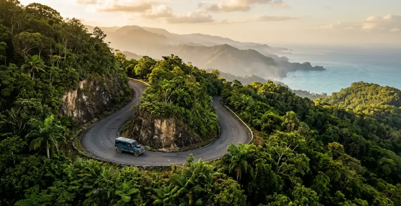
The Navigation Mistake That Adds 4 Hours to Your Drive to Pedernales
Now for the most critical piece of fixer intelligence. The drive to Pedernales and the iconic Bahía de las Águilas is the crown jewel for many independent travelers. It’s also where the most common—and most dangerous—navigation mistake is made. The Dominican Republic has the unfortunate distinction of being a challenging place to drive; a report cited by the World Health Organization noted that 29 out of every 100,000 people died in road accidents annually, making it one of the most hazardous in the hemisphere. This isn’t meant to scare you, but to underscore the importance of smart navigation.
The mistake happens when leaving Barahona for Pedernales. Your GPS, whether it’s Google Maps or Waze, will likely show you a tempting “shortcut” that cuts directly through the Sierra de Bahoruco National Park. On the map, it looks like a clever way to save time. Do not take this route. This is a “phantom shortcut,” a poorly maintained, often unpaved road that requires a high-clearance 4×4 and advanced driving skills. It is notorious for causing flat tires, getting vehicles stuck, and adding four or more hours to the journey. There are no services, no cell signal, and no help for miles.
The correct and safer route is to follow the well-paved coastal road (Route 44) through Oviedo. It may look longer on the map, but it is faster, safer, and infinitely more reliable. This single piece of knowledge can be the difference between an incredible scenic drive and a stranded-on-the-side-of-the-road disaster. It exemplifies the core principle of Dominican road-tripping: trust local knowledge over technology.
Preparation is everything for this leg of the journey. The remote nature of the drive means you are your own first responder. Before you even think about heading south from Barahona, you must ensure you are properly equipped.
Your Action Plan: Navigating the Pedernales Route Safely
- Refuel Completely: Fill your tank in Barahona. Gas stations become extremely scarce as you head further south.
- Download Offline Maps: Before losing signal, download the entire region on Google Maps or Maps.me, ensuring you have the coastal route (Route 44) saved.
- Verify the Route: Explicitly follow the coastal road via Oviedo. Ignore any “shortcut” that routes you inland through the national park.
- Check Your Spares: Physically inspect your spare tire and ensure you have a functional jack and lug wrench. This is non-negotiable.
- Pack Emergency Supplies: Carry at least two gallons of water, non-perishable snacks, a basic tool kit, and have the CESTUR (tourist police) number (809-200-3500) saved.
3 Provinces You Must Prioritize if You Have Fewer Than 7 Days
If you’re short on time, trying to see everything is a recipe for exhaustion. A successful week-long road trip is about strategic choices, not a mad dash across the country. With seven days, you can have a rich and diverse experience, but you must focus on a logical route that minimizes backtracking and avoids unrealistic drive times. The key is to create a “golden triangle” that combines the country’s three core experiences: colonial history, mountain landscapes, and coastal beauty.
For a tight schedule, the most efficient itinerary prioritizes the central and northern regions. A smart plan would look something like this:
- Santo Domingo (Distrito Nacional): Start in the capital. Spend a day or two exploring the Zona Colonial, the historic heart of the Americas. Pick up your rental car on the way out of the city to avoid its chaotic traffic.
- Puerto Plata: From Santo Domingo, drive north. This route takes you through the spectacular Northern Mountain Range (Cordillera Septentrional) with stunning views of the Cibao Valley. This positions you perfectly to explore the beaches and attractions of the North Coast.
- Santiago (Santiago Province): As you loop back towards the capital, route through Santiago de los Caballeros. It’s the country’s second-largest city and the economic hub of the fertile Cibao Valley, offering a glimpse into the urban, non-tourist side of Dominican life.
This itinerary is manageable because the main roads connecting these three points are generally well-maintained. However, don’t let the relatively short distances on the map fool you. A 200km drive is not a two-hour affair in the Dominican Republic.
Understanding realistic travel times is crucial for any road trip planning. Traffic, road quality, and unexpected delays are all part of the experience. The following data provides a much-needed reality check for planning your daily drives.
| Route | Map Distance | Realistic Drive Time | Key Challenges |
|---|---|---|---|
| Santo Domingo – Puerto Plata | 215 km | 3-4 hours | Traffic leaving capital, mountain curves |
| Puerto Plata – Barahona | 380 km | 6-8 hours | Multiple city transits, road conditions vary |
| Santo Domingo – Punta Cana | 200 km | 2.5-3 hours | Good highways, tourist traffic near resorts |
| Santo Domingo – Jarabacoa | 155 km | 3-4 hours | Mountain roads, steep inclines, narrow passages |
| Punta Cana – Samaná | 320 km | 5-6 hours | Cross-country route, varied road quality |
As this analysis of Dominican Republic itineraries shows, a route that looks simple on paper can be a full day’s journey. By focusing on the Santo Domingo-Puerto Plata-Santiago triangle, you create an ambitious but achievable 7-day road trip that delivers a powerful taste of the country’s diversity without spending all your time behind the wheel.
How to Access the Most Dramatic Landscapes of the Peninsula Safely?
The Pedernales Peninsula, home to the jaw-dropping Bahía de las Águilas, is the ultimate reward for the adventurous road-tripper. This is not an easy destination to reach. Unlike the 1.5-hour drive from Punta Cana to Miches on the east coast, reaching the far southwest requires a commitment of 6 or more hours from any major tourist hub. The isolation is precisely what preserves its stunning, untouched beauty. But this isolation also demands a higher level of self-sufficiency and safety awareness. Accessing these landscapes safely is entirely about preparation.
Your primary lifeline in this remote region is your vehicle. Before departing Barahona, it is not enough to simply check your gas gauge. You must conduct a thorough vehicle check: inspect all tires for wear and proper inflation, confirm your spare tire is in good condition, and know how to use your jack. Cell service is spotty at best and non-existent in many areas. You cannot rely on calling for help. Informing someone at your hotel of your intended route and estimated return time is a simple but critical safety measure.
Once you arrive in the small town of Pedernales, the final leg to Bahía de las Águilas typically involves hiring a small boat from the fishing village of La Cueva. This is the recommended method, as the final stretch of road is extremely rough. While there, you are completely off the grid. There are no restaurants, no shops, and no facilities. You must bring everything you need with you—and pack everything back out.
This is a place where nature is still in charge. To ensure your trip is memorable for the right reasons, your focus must be on emergency preparedness. You are your own support system.
- Water and Food: Carry a minimum of two gallons of drinking water per person for a day trip, plus more than enough non-perishable snacks like nuts and energy bars.
- Communication: Download offline maps for the entire region. Have the CESTUR tourist police emergency number (809-200-3500) saved in your phone, but do not rely on having the service to call it.
- Basic Skills: Know basic Spanish phrases for emergencies, such as “Mi carro está dañado” (My car is broken) or “Necesito ayuda” (I need help).
How to Plan a Mountain Retreat in the Central Cordillera?
No Dominican road trip is complete without trading the coastal heat for the cool, crisp air of the Central Cordillera. The towns of Jarabacoa and Constanza are the heart of the Dominican “Alps,” offering a completely different world of pine forests, coffee plantations, and roaring waterfalls. This is the country’s adventure capital, a haven for hiking, rafting, and canyoning. Planning a retreat here requires a shift in mindset and packing list, as the mountains present their own unique set of logistical challenges.
The primary consideration is your vehicle. While you can reach the main towns with a standard car, exploring the region’s true beauty often means venturing onto unpaved side roads to reach trailheads and hidden gems. For this, a 4×4 or a vehicle with high clearance is highly recommended. The mountain roads between Jarabacoa and Constanza are known for steep inclines, sharp curves, and narrow passages. Recent erosion and the potential for landslides, especially after heavy rain, make a capable vehicle essential for both safety and peace of mind.
The climate is another critical factor. While the coast sizzles, temperatures in the mountains can drop significantly, especially at night, sometimes reaching as low as 10°C (50°F). Packing for the coast will leave you shivering. Your packing list must include:
- Warm layers like sweaters, long pants, and a proper rain jacket.
- Closed-toe hiking shoes with good grip, as trails can be wet and muddy.
- A flashlight or headlamp, as power outages can be more frequent in these remote areas.
Finally, embrace the mountain economy. Services are more limited here. Stock up on gasoline and any essential supplies in a larger city like La Vega before you ascend. Many of the charming eco-lodges and local restaurants in the mountains do not accept credit cards, so carrying enough cash in small denominations is crucial. Planning a mountain retreat is about preparing for cooler temperatures, rougher roads, and a more rustic, cash-based way of life. It’s a rewarding detour that adds an entirely new dimension to your understanding of the island.
Key Takeaways
- Never trust a GPS “shortcut” in remote areas; always stick to confirmed, well-traveled coastal or main roads.
- The infrastructure gap is real: services like gas, police, and hospitals are abundant in tourist hubs but scarce elsewhere. Plan accordingly.
- A 4×4 or high-clearance vehicle isn’t a luxury but a necessity for safely exploring the mountain regions or remote peninsulas.
How to Reach the “Secret” Beaches of the North Coast Without a Guide?
The North Coast, stretching from Puerto Plata towards the Samaná Peninsula, is legendary for its string of stunning beaches. While some are fronted by large resorts, the real magic lies in discovering the “secret” spots that most tourists miss. Finding these hidden coves and pristine stretches of sand without a guide is one of the most rewarding parts of a self-driven tour. The key isn’t a secret map, but a combination of a capable vehicle, a bit of adventurous spirit, and knowing what to look for.
Many of the best beaches, like Playa Caletón or Playa Grande, are surprisingly accessible, located just a short walk from the main coastal road. They often feature small, local food stands serving fresh fish and cold beer—the perfect authentic beach day. However, other gems like Playa Diamante require navigating down bumpy dirt roads where a standard rental car might struggle. Experienced travelers often note that while the highways between cities are manageable, they are riddled with potholes and cracks, and Dominican drivers can be very assertive. For this reason, comprehensive insurance on your rental car is essential for peace of mind.
Your best tools for discovery are a combination of offline maps and a willingness to explore. Look for small, unmarked turn-offs from the main road between Cabrera and Río San Juan. Don’t be afraid to ask locals; a simple “¿Dónde está la playa?” can lead you to a place you’ll have all to yourself. Some of the most spectacular locations, like the El Saltadero waterfall, require a short hike, so having sturdy shoes in your car is always a good idea. The adventure is in the search, and the North Coast rewards those who are willing to look beyond the obvious. It’s the perfect way to cap off your road trip, putting your hard-won navigation skills to the test to find your own private piece of paradise.
With this fixer’s guide in hand, you are no longer just another tourist. You are an informed, prepared, and strategic explorer, ready to experience the authentic beauty and thrilling diversity of the Dominican Republic. It’s time to start planning your route, not by the dots on a map, but by the adventures that lie between them.